
Day 10: August 29, 2018
Route: Mitchell, Oregon, to Prospect, Oregon
The sounds of the creek next to my camp were very relaxing, and I slept well. I broke down camp around 8 a.m. and got on the road westbound on Highway 26. A few miles west of Mitchell, I turned off toward the Painted Hills. The turn-off, Bridge Creek Rd., was nicely paved and twisty, following the sinuous path of Bridge Creek through its valley carved through the foothills of the Sutton Mountains. I passed a few small farms along the way. I turned onto Bear Creek Rd. to make the one-mile climb over the loose gravel into the Painted Hills.


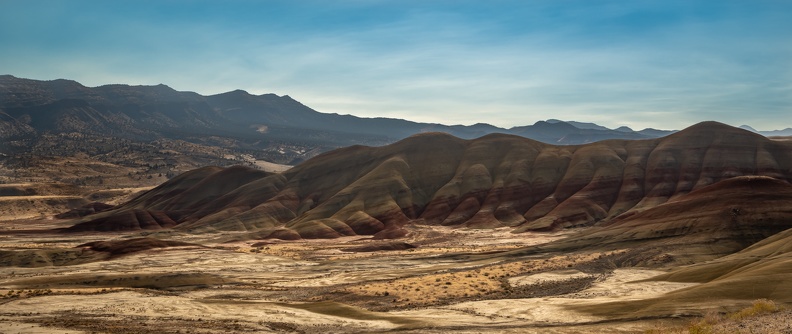

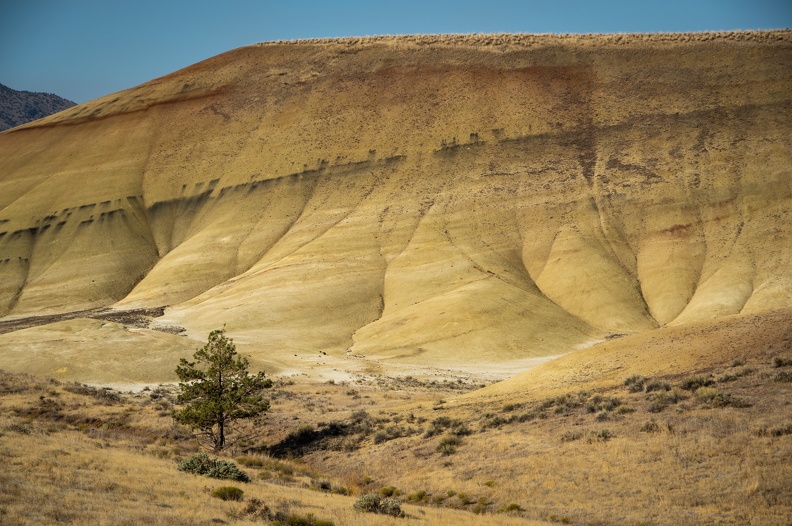
At the overlook, I was graced with a wonderful view of the Painted Hills. The hills were rich with multiple shades of red, gray, orange, and brown – the layers representing various geological eras and deposits laid down when the area was a river floodplain. With the sun still low in the morning sky, the colors were very rich, but I could only imagine what the colors would look like as the sun was on its way down in the west. I should have made the trip yesterday afternoon before calling it a night.
I headed back to Highway 26 and continued west into the Ochoco National Forest. Highway 26 climbed Ochoco Pass then descended into agricultural areas of the Prineville Valley. As I continued towards Bend, the volcanic origin of the area know as the High Lava Plains was very evident. Farms had small outcroppings of volcanic rock randomly dispersed throughout, and small buttes and ancient cinder cones were visible all around.
Just west of Prineville, I turned onto Oregon Highway 126, which climbed from the Prineville Valley into the High Lava Plains, the brown soil and yellow scrub, a stark contrast from the green farms of the valley.
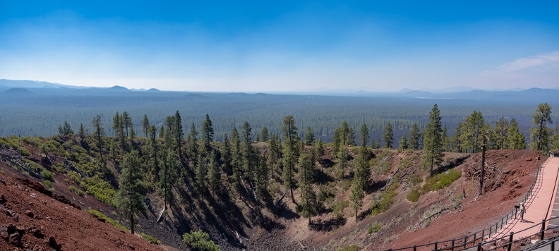
I gassed up in Bend and got onto US Highway 97 to head south to Crater Lake. A few miles south of Bend, I stopped at the Newberry National Volcanic Monument. The Newberry Monument protects the areas around the Newberry Volcano and includes more than 50,000 acres of lava flows. The visitor center is located at the base of Lava Butte, a 500-foot-tall cinder cone that was created in an eruption about 7,000 years ago. Lava Butte is surrounded by lava flows associated with its eruption, stretching 5 miles from the cone to the Deschutes River. I rode the bus to the top of the cone and took in panoramic views of the surrounding lava flows and the Newberry Caldera to the southeast.


After leaving Lava Butte, I continued south on Highway 97, where winds picked up across the vast lava plains. Most of the time, the winds came from the west, blowing down from the Cascades, but on occasion I felt the wind become indecisive and change directions.
I turned off toward Crater Lake at Chemult, where Oregon Highway 138 – The Volcanic Legacy Scenic Byway – meets up with Highway 97. I entered Crater Lake National Park via the east entrance. The road crosses the Pumice Desert on its climb up the flanks of the former Mt. Mazama, the volcano that contains Crater Lake in its caldera. In my past visits to Crater Lake, the entire area has been covered in snow – in winters the national park is often covered in 10 to 15 feet of snow – so seeing the area covered in grasses and trees was different from my “usual.”


About 8 miles past the entrance station, I reached Rim Drive. I pulled into a surprisingly empty viewpoint and my jaw dropped. The view of the lake was breathtaking. Seeing the lake from the back of a motorcycle was one of those experiences that gets you right in the feels. I might have started tearing up at the beautiful deep blues of the lake surrounded by the rich reddish-brown crater walls. Just a week prior, the view of the lake was obscured by heavy smoke. Today, the skies were all but devoid of any smoke. Seeing the lake in this way was like seeing it again for the first time.


I continued to the Rim Village Visitor Center and got another stamp for my National Parks Passport book, my ninth stamp of this trip. Walking around the parking area at Rim Village seemed strange, given that I had only been here in winter before and had only seen the parking lot surrounded by tall walls of snow.
I exited the park and stopped at the Joseph Stewart State Park on the shores of Lost Creek Lake for the penultimate night of the trip. The park was essentially empty, except for a few RVs and trailers, so there were plenty of sites to choose from. All sites have electrical and water hookups (if you’re honest and pay the $24 fee). Each of the loops at the campground surrounds a central building with sinks for washing dishes, bathrooms, and showers within a few yards of each site. The park looked like a great place for families as well, with several children’s playgrounds around the campground.
I sat by my tent looking up at the stars, contemplating my journey and how the entire trip felt. I’ll cover those thoughts later.

One more day to go.
Distance: 240 miles, 2,329 total.