
Day 9: Tuesday, August 28
Route: Hood River, Oregon, to Mitchell, Oregon
I slept like a baby in the king-size bed in my hotel room. I got up and opted for the complimentary breakfast. I’ve only seen these at Holiday Inns, but they had an automatic pancake machine. This marvel of technology lets you push a button on one end and receive fresh pancakes from the other end in about two minutes.

I got a bit of a late stop on the road, finally rolling out around 10:30. I went south on Oregon Highway 35 into the Mount Hood National Forest. Clear skies made for great views of Mt. Hood. I turned off onto Forest Service Highway 44, which connects Highway 35 to US Highway 197 at Dufur. Soon the pine forests turned into rolling hills covered with grass.

Highway 197 followed the ups and downs of the land, climbing up Tygh Ridge before descending into Butler Canyon. Butler Canyon opened into the Tygh Valley, then the road climbed Juniper Flat – a plateau bounded by the White River on its north side and the Deschutes River on the east. On the south side of Juniper Flat, Highway 197 descended into the Deschutes River Canyon and the city of Maupin.

After leaving Maupin, Highway 197 climbed another plateau, topping out at Criterion Summit before meeting up with Highway 97 and dropping into Cow Canyon. At the bottom of Cow Canyon, I turned off onto Oregon Highway 293, which wound its way through the Antelope Creek Canyon toward the city of Antelope.


I should have done some research beforehand, because Antelope is a nearly abandoned city. The city, formed in 1901, rose to some notoriety in the 1980s when members of the Rajneesh movement, a controversial religious movement based on the teachings of Indian guru Bhagwan Shree Rajneesh. In the early 1980s, the Rajneesh movement moved into Antelope, and effectively took over the city government by outnumbering the original residents through new voter registrations. Antelope was renamed to Rajneesh in 1984. In 1985, several of the Rajneesh movement leaders were implicated in criminal behavior, including a mass food poisoning attack and a plot to assassinate a US Attorney. Shortly after, the Rajneesh commune in Antelope collapsed and the city was renamed to its original name. A large number of abandoned buildings stand decaying in the city. Had I known all this, a stop would have likely been in order.
Highway 293 twisted its way through the Antelope Creek canyon. The canyon opened up to a valley of rolling hills dotted buttes and edged with steep-sided cliffs. At Antelope, Highway 293 met up with Oregon Highway 218, which runs to Fossil.


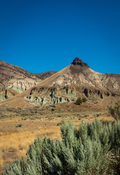
Highway 218 ran past the Clarno Palisades, one of the three parts of the John Day Fossil Beds National Monument. The monument was established in 1975, and is well-known for well-preserved layers of fossil plants and animals that lived in Eastern Oregon between 5 and 45 million years ago. The area around the Palisades was like riding through a John Ford movie. The highway wound its way around the base of exposed rock formations more reminiscent of the American Southwest than what one things of the Pacific Northwest. I stopped at the picnic area for the Clarno Palisades for a stretch.


The Clarno Palisades are about 18 miles west of Fossil. They are made of ancient volcanic lahars, pyroclastic mudslides, that formed between 40 and 54 million years ago when the area was a semi-tropical rainforest. Researchers have found fossils of ancient four-toed horses, rhino-like brontotheres, crocodiles, and other jungle animals in in the rocks around the palisades.
I walked around for a bit, stretching my legs and drinking water to stave off dehydration. While walking around, a couple of BMWs rolled into the parking lot. The riders were visiting the area from Alberta, and had actually been at Horizons Unlimited! Small world!
I was still about 70 miles from the main Fossil Beds Visitor Center, a drive which a sign at the palisades said was two hours long. I looked at the time and saw I would be cutting it close to the center’s closing time. I bid farewell to the Canadians and made tracks for the visitor center.
Making great time is hard when the scenery is so amazing! Dropping down into Fossil the road twisted through small canyons, occasionally giving views of the Butte Creek Valley below. From Fossil, I turned onto Oregon Highway 19, the “Journey Through Time” Scenic Byway, which followed Butte Creek, one of the many tributaries feeding the John Day River.
Just south of Spray, Oregon, I ran into construction on Highway 19. The road was ground up for repaving, but I didn’t see anyone working on actually paving the road. The loose gravel on the road from grinding and preparation for chip sealing was thick at times, keeping speeds down. I kept my bike in the wheel tracks that had been worn into the gravel, but occasionally those tracks disappeared. Ten miles passed with no sign of workers, then 20 miles passed with no sign of road workers. Who grinds up 20+ miles of road at a time before paving? Finally, as I neared the Fossil Beds Visitor Center, the workers appeared – nearly 30 miles from the start of the construction zone.


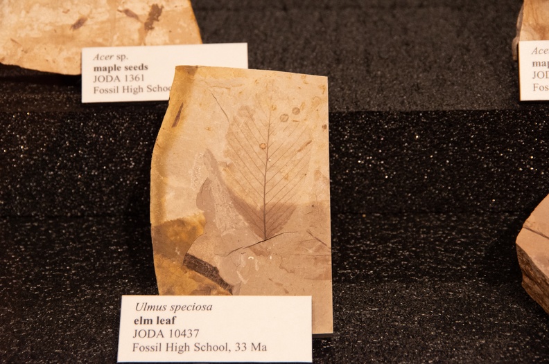
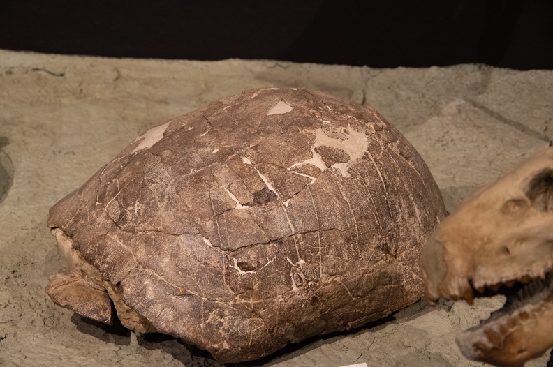
I stopped at the Thomas Condon Paleontology Center, in the shadows of Sheep Rock. The Condon Center is the main visitor center for the Fossil Beds National Monument. The center has many fossils on display of plant and animal life that used to make Eastern Oregon home. The area around Sheep Rock was where Army soldiers first found a multitude of fossils while searching for gold in 1865. The paleontology center is named for Thomas Condon, who accompanied the soldiers to the area after learning of the fossil finds.


After seeing the visitor center, I went south on Highway 19 for a few miles and turned onto US Highway 26 toward Mitchell. Highway 26 runs through Picture Gorge, a narrow canyon cut through deep layers of Columbia basalt lava flows by the John Day River and Rock Creek. The canyon was named for the Native American pictographs found on the canyon walls.

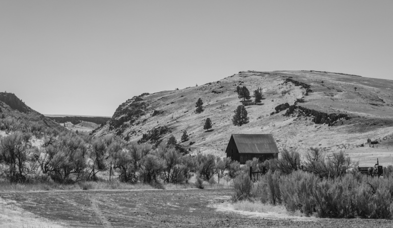
I stopped for the night in Mitchell, Oregon (population 130). Mitchell was founded in 1873 and sits at the bottom of a small canyon. The city calls itself “The Gateway to the Painted Hills” because it’s the only city in relatively close proximity to the Painted Hills Unit of the John Day Fossil Beds National Monument.
I stopped into the Mitchell Stage Stop for dinner and to use the WiFi. The building looked almost as old as the city itself. I ordered myself a bacon jalapeno cheeseburger and fries. The burger was enormous and delicious. My can of soda was cold and was given to me accompanied by a glass mug pulled directly from the freezer.


Across the street from the Stage Stop was the Mitchell City Park. The city allows RV and tent camping at the park, and it’s a popular stop for bicyclists riding through the area. I set up my tent along side a gurgling creek and had the whole park to myself for the night.
Distance: 250 miles, 2,089 total.